Crowle Charities
The entries in the Crowle Survey of 1738

Walkwood’s Dole
From the Enclosure Plan.

Plan of the property on Church street in 1738. (North to top of plan)
The manorial plan shaded charity property Green and in the survey is described as; “54, In Hand, Mr Richard Clarks copy House, School and Gardens”. As listed in the survey Clarks School in Lords Hands, “54, A Dwelling House, Yard, School & Garden”

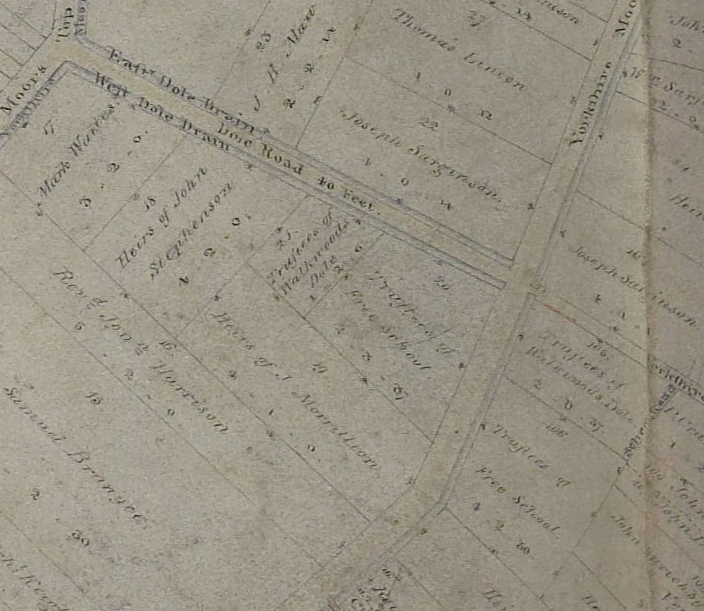
Plan of Walkwood’s Dole House (75) opposite the Red Lion (130) (North to left of plan)
As listed in the terrier, “75 Walkwoods Dole, A Cottage House, Homestead & Garden”. As listed in the survey, Walk woods Dole, “75, A Dwelling House, Homestead & Garden”
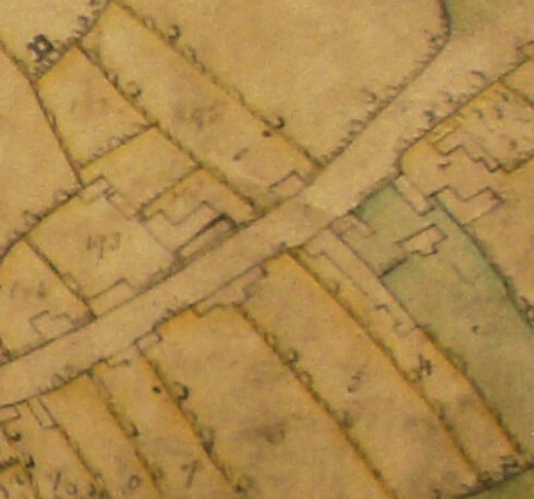
Town Farm coloured in Green on Wharf Road.(North to left of plan)
As listed in the Terrier, “3, The Town Farm Formerly Mr Richard Brewers now in hand, it consists of a Cottage house, Barne Stables & Croft.” As Listed in the survey, The Brewers School in Lords Hands “3, The Town Farm formerly Mr Richard Brewer, The Schoolhouse, Homestead & Home Close”. This would appear to be the current site of 33 Wharf Road.
This was a work in progress and should not have been visible!. I have most of the basic stuff from the histories but have been pulling together further information from the National Archives for a presentation I said I will pull together for the Family History Society. The 1738 Plan indicates that there were at that time 2 school buildings the one on Church Street – which was from Brewers bequest if I remember correctly and one on Wharf Road. Walk woods bequest also included a building opposite the Red Lion. The plan on this page was showing some of the land owned by the Walkwood Charity (or Dole) on Dole Road.
The charities are formalised in the mid 19th century when a new charity arrangement was agreed. I have only discovered recently that the church still have some income from these charities so I need to investigate further.
I want to find out more about the people behind the bequests Richard Clark was apparently the Nephew of Richard Brewer as he refers to his Uncle Brewer. but still having trouble determining more about their professions etc – I think there are some inventories that might help.
Some interesting stories coming out of the National Archive files including a Drunken Headteacher, Allegations of the Vicar (who was declared Bankrupt) pocketing several years income from the charities and the local authority in the early 20th C insisting that a teacher have her salary reduced!
There is further info – still work in progress and photos of a sign that is in the Church Tower relating to Walkwood’s bequest.
https://crowle.org/?p=191
Any further information that you, or any one else has, would be most welcome!
Thomas Walkwood surrendered five acres and twenty perches of land, lying in Ealand and Crowle field, with the messuage where he lived, with orchards, building and stables belonging to it, to the ministers and churchwardens of Crowle and their suceesors for the use of the poor. He also gave two acres and twenty perches of land in Crowle field the rent on which was to be used by the minister and churchwardens and their succesors for the education of poor children of the parish. The deed was “FOR EVER”. In 1839 the estate was let for £15 per annum.
Richard Brewer of gainsborough in 1687, left amessuage and farmhouse ifn Crowle, with arable land meadow and pasture, known as Town End farm. in 1839 it was let for £44 per annum.
Another bequest was mad e by Richard Clark in 1721.
Originally there were 32 pupils and the master received £32 plus an allowance for coals, by 1858 the number had risen to 50. Three years previously the delapidated schoolhouse had fallen down and the pupils were taught in the church vestry, by a MR. Thomas Hodgson.
The further progress of these charities and the devlopement of education is usually recorded the details about Crowle in the various directories published in the nineteenth century. The building of what eventually became the Church of England School still exists today on Church Street and still used by the community. Angus can no doubt supply it’s current name.